
A geographic information system is not built entirely from scratch. Invariably, new work incorporates pre-existing datasets chosen for their robustness and relevance to the topic under investigation. The work of rounding up reference-quality spatial data is the geospatial technology equivalent of an academic literature review. Unfortunately, we need to confront the “rounding up data” learning curve before moving on to the actual construction of a geographic information system. Let’s use a hypothetical situation to illustrate the process. Assumptions:
- We’re using a workstation attached to the UWGB Network and running ArcGIS Desktop.
- We have a bunch of Wisconsin data points and one of our project objectives is county-level analysis of the data.
The most direct way to make the necessary accomplish this is to find an Esri shapefile or geodatabase feature class from a reputable source and copy it into the project workspace. The upside of this approach is that the components of our GIS are being gathered in one location and the hassle of finding individual pieces later is reduced.
Data Files Accessed “In Place” – The local storage approach described above has a huge downside. It’s a given that the project workspace is on rigorously backed up local hard drives or shared network drives. This kind of space is often scarce and expensive. To the extent possible it should be reserved for files created specifically for the project. with automaticdd backed up on drives can result in chewing up disk space needed for project workspace needs to be on a disk is scarce
| Feature Class Source | Data Access Details |
|---|---|
| The Biodiversity Center's Geodata Library (K Drive Subset) | The so-called "K-drive" is a share on the UWGB network configured for static storage. Mapping the share enables the user to add spatial databases stored there to an ArcMap map document open on his/her machine. Map the campus computer network's K drive 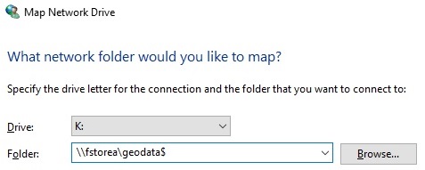 In Windows File Explorer: In Windows File Explorer:
|
| Internet download portals | Say we are building a geographic information system and we've identified a specific dataset that's essential to the tasks we want to accomplish with our GIS. is needed for the that is under construction may be via download portals. Standard Internet search tools are used to find the specific datasets that meets the needs of s needed to round out need, one approach There are thousands of download portals. Finding the ones that serve up the particular datasets needed for the GIS that is being constructed can be quite a challenge. Once found, the needed datasets are downloaded to local or network drives. Check out our Selected Download Portals web page for a list of sites that we've found useful in our work. |
| Link to an Internet map service | Locate the "service end point" for the needed data file(s). That's the Internet address or URL that and link to them them to a local or network drive. Check out our Selected Download Portals web page for a list of sites that we've found useful in our work. |
| Network Library - Locate the needed data file(s) on a local network drive such as UW Green Bay's Geodata Drive. | "Frozen" data files stored on a network drive |
| Local Data Collection - Locate the needed data file(s) in a local collection such as the GEODATAFIX Section of UW Green Bays Geodata Archive. | DIY |
Download files from data distribution websites - |
Finding and Vetting Reference Data – Knowing where to look – government hosted download portals and services. Knowing what to look for – Does metadata exist? What does it say about the robustness and timeliness and Reviewing Metadata The “old-fashioned” approach to collecting the reference data needed for a particular geographic information system is to take possession of the datafiles and store them on a local or network drive connected to the author’s workstation. More recently, many databases have been published as streaming map services.
 Reference Data Held and Curated At UW-Green Bay – In response to the needs of natural sciences faculty and students, the Cofrin Center for Biodiversity has been collecting and storing spatial data since 2003. The scope and design of the CCB’s spatial data library has evolved over time and it is currently referred to as the “Geodata Archive”.
| UW-Green Bay Geodata Archive - Completed GIS Jobs - This article describes the section of the Archive containing the working files and deliverables generated in the course of completing past jobs. CHECK IT OUT |
|
| UW-Green Bay Geodata Archive - Uncataloged GIS Data - This article describes the section of the Archive that serves as a holding area for post-project file dumps and material received from data-sharing partners. CHECK IT OUT | |
| UW-Green Bay Geodata Archive - Fixed and Filtered GIS Data - This article describes the section of the Archive devoted to "ArcMap ready" spatial databases. CHECK IT OUT | |
| The Biodiversity Center's Geodata Drive - Easy Access to ArcMap Ready GIS Data - This article describes the Geodata share on UW-Green Bay's fstorea server. The share contains a large subset of the Biodiversity Center's ArcMap ready datasets. CHECK IT OUT |
|
| Geodata Archive - January 2018 Status Report - Organization and status of the UW-Green Bay Geodata Archive. CHECK IT OUT |
Note that this material (web page section titled “Reference Data Held and Curated At UW-Green Bay” and its linked articles) constitute the best available owner’s manual for the Geodata Archive. Technically the material belongs on a Biodiversity Center-owned website and that is where it was developed and published until early 2016. Unfortunately that option became unavailable at the same time the content needed a substantial update. To make sure the most recent information was available to users of the archive, we recreated the owner’s manual here on ottergeospatial.info. I know that the Biodiversity Center leadership is strongly committed to documenting their work and have a strategy in mind for getting this content back on to a Biodiversity Center-owned website. In the meantime we’ll maintain the information on our site and try to keep up with new developments.
Printed Air Photos and Maps – Some air photos and maps, even though not georeferenced at publication, qualify as reference data. Digital images (including scans of paper originals) can be zoomed, rotated and warped so that they are displayed in their proper place on the earth’s surface. Of course the originals need to meet certain technical criteria and the information they contain must be worth the required computer work, but there are lots of paper maps and raw digital images that fall in to that category.
| About Printed Maps and Air Photos - This Otter Geospatial RefDoc article discusses the importance of unreferenced material. CHECK IT OUT | |
| Great Lakes Oblique Imagery - This Army Corps of Engineers viewer and download portal is used to distribute a collection of shoreline oblique photographs snapped in 2011-2012. This EXTREMELY VALUABLE AND INFORMATIVE collection was commissioned by FEMA as part of their Great Lakes Flood Hazard Mapping Program. CHECK IT OUT | |
| Office of Coast Survey Historical Map & Chart Collection - This National Oceanic and Atmospheric Administration viewer/download portal is a clearinghouse for historic navigation charts and related maps going back to the late 1800s. CHECK IT OUT | |
| La Baye - This collection of documents relevant to the pre-settlement history of the region is an important historical reference. It's also a great destination for people who really like old maps. CHECK IT OUT | |
| Wisconsin Public Land Survey Records - This document collection includes original field notes and plat maps from the so-called "original survey". CHECK IT OUT | |
Text Reports and Tabular Data – Not all important spatial data is published as standard spatial databases. We need to know where that material resides and how to plug it in to our work products.
| FIA Data Mart - This US Forest Service download portal is used to distribute data from the Forest Inventory and Analysis Program CHECK IT OUT |
|